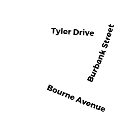
22-R BURBANK STREET
Owner Information
ABREU, ROBERT C & KATHERINE E
22 BURBANK STREET
SANDWICH, MA 02563


Property Details
22-R BURBANK STREET is classified as a Undevelopable Residential Land.
22-R BURBANK STREET is valued at $1,400. The land is valued at $1,400 and the structures are valued at $0.
This property is in Zone R1. Confirm with local Zoning Board authorities to ensure there are no overlays or other easements on this property.
The most recent deed for 22-R BURBANK STREET is recorded at the local registrar in Book LAND, Page COURT. 22-R BURBANK STREET was last sold on Friday, April 12, 2013 for $235,000.
Assessment data from fiscal year 2022.
Flood Data
According to the FEMA National Flood Hazard Layer, this property does not appear to be in a flood zone. It may also be in an area not yet reviewed. Nonetheless, confirm this information prior to taking any action.
To view the flood hazards around this property, create a FEMA "Firmette" Map of the area around 22-R BURBANK STREET.
Broadband Internet Providers
| Provider | Type | Bandwidth (mbps) | |
|---|---|---|---|
| Viasat Inc | Satellite | 35 | 3 |
| VSAT Systems, LLC. | Satellite | 2 | 1 |
| Verizon New England Inc. | DSL | 10 | 1 |
| Comcast | Cable | 1000 | 35 |
| GCI Communication Corp. | Satellite | 0 | 0 |
| HughesNet | Satellite | 25 | 3 |
Broadband service provider data from December 2020.
Adjacent Properties
- 46 ROUTE 6A
Eating and Drinking Establishments - restaurants, diners, fast food establishments, bars, nightclubs owned by GREAT FOOD REALTY TRUST - 24 BURBANK STREET
Single Family Residential owned by OTTANI FAMILY LIVING TRUST - 22 BURBANK STREET
Single Family Residential owned by ABREU, ROBERT C & KATHERINE E - 23 TYLER DRIVE
Single Family Residential owned by AHONEN, ROBERT N & JANICE D